The Winter Weather Advisory is Cancelled!
Update from the National Weather Service on November 30, 2022, at 6:05 pm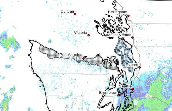
Winter Weather Advisory in Effect Until 4 pm Thursday, December 1, 2022, at 4 pm
Expecting
1 to 3 inches of snow accumulation
Where
Admiralty Inlet Area, including Port Townsend, Whidbey Island, and Camano Island, Eastern Strait of Juan de Fuca lowlands, including Port Angeles, Sequim, and Blyn and Western Strait of Juan de Fuca lowlands, including Sekiu, Clallam Bay, and Joyce.
Impacts
Plan on slippery road conditions. Be safe. Slow down and use caution while traveling.
Update from the National Weather Service on November 29, 2022
- Decreased snow risk on Tuesday, November 29 and Wednesday, November 30 morning
- Temperatures will increase on Tuesday night.
- Increased wind risk through Wednesday
Wednesday, November 30
- Light snow showers expected in the morning through the afternoon and evening
- Heavy snow expected in the mountain areas
Puget Sound Energy (PSE) Update on November 29, 2022 at 1:31 pm
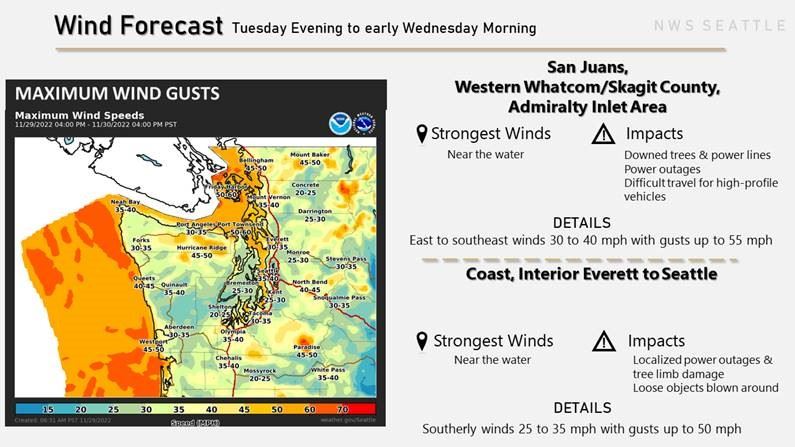 The National Weather Service has issued a winter storm warning and a high wind warning for Western Whatcom/Skagit County and Admiralty Inlet area now through the afternoon of Wednesday, Nov. 30. Expect east to southeast winds 30 to 40 mph with gusts up to 55 mph near the water.
We’re closely watching the forecast, as wind and heavy snow can cause tree branches to fall into power lines. Our crews are prepared and ready to deploy with assignments when outages occur and as soon as it’s safe to do so.
As we prepare for storm conditions, we encourage our customers to do the same:
- Make sure to have emergency supplies on hand at home and in your vehicle, such as extra batteries, flashlights and food.
- Have a battery-powered radio ready to go.
- Charge cell phones and mobile devices in case the power goes out.
- Avoid opening and closing refrigerators and freezers more often than necessary. A closed refrigerator will stay cold for up to 12 hours.
- Turn off lights and unplug all appliances and sensitive electronic equipment, such as computers, to prevent an overload on your circuits when electric service is restored. Leave one light on to let you know when service returns.
- Download the myPSE app to track and report outages, check status and get estimated restoration times, or visit pse.com/outagemap.
- Get additional information on ways you can prepare and more about how power gets restored at:
Safety first:
- Never touch or go within 35 feet of downed power lines because they might be energized. Call PSE at 1-888-225-5773 or 911 to report problems.
- Do not use a charcoal or gas grill to cook indoors. Never use a natural gas range for heating, or charcoal as an indoor heating source. This can cause a buildup of poisonous carbon monoxide gas.
- If you choose to use a portable home generator, read the manufacturer’s instructions for the safe operation of the generator. Do not operate generators indoors or in enclosed spaces to avoid the build-up of carbon monoxide.
- If you’re using portable heaters, keep them away from furniture, draperies and other flammable materials.
- Always use flashlights instead of candles.
Upcoming weather forecast from the National Weather Service (Monday, November 28, 2022)
Monday, November 28, 2022 Forecast
Increasing clouds, with a low around 28. North wind 5 to 13 mph, becoming east-southeast after midnight.
Tuesday, November 29, 2022 Forecast
A chance of snow showers between 11 am and 1 pm, then a chance of snow after 1 pm. Cloudy, with a high near 38. Wind chill values between 23 and 30. Southeast wind 9 to 17 mph, with gusts as high as 24 mph. 50% chance of precipitation. New snow accumulation of less than a half inch is possible.
At night, expect rain and snow, becoming all rain after 1 am. The temperature rises to around 38 degrees by 4 am. Wind chill values between 21 and 28. Breezy, with a southeast wind of 22 to 26 mph, with gusts as high as 37 mph. 100% chance of precipitation. New snow accumulation of less than a half inch is possible.
Wednesday, November 30, 2022 Forecast
High near 44. South wind 6 to 10 mph. The chance of precipitation is 90%. New precipitation amounts between a tenth and a quarter of an inch possible. By Wednesday night, rain is likely before 10 pm, then rain and snow are also likely. Mostly cloudy, with a low of around 30 degrees. East-southeast wind around 9 mph. The chance of precipitation is 70%. Little or no snow accumulation is expected.
Thursday, December 1, 2022 Forecast
A chance of rain and snow. Partly sunny, with a high near 40. The chance of precipitation is 50%. Little or no snow accumulation is expected.
Weather Tips
The City website provides winter weather tips online.
Priority Snow Plow Maps
Check out the map showing priority sanding, de-icing, and snow removal routes.